


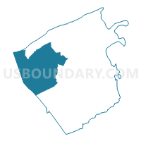
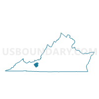
Robinson Voting District, Pulaski County, Virginia
About
Outline

Summary
| Unique Area Identifier | 682402 |
| Name | Robinson Voting District |
| County | Pulaski County |
| State | Virginia |
| Area (square miles) | 61.28 |
| Land Area (square miles) | 60.86 |
| Water Area (square miles) | 0.42 |
| % of Land Area | 99.31 |
| % of Water Area | 0.69 |
| Latitude of the Internal Point | 37.06936070 |
| Longtitude of the Internal Point | -80.83398500 |
Maps

Graphs
Select a template below for downloading or customizing gragh for Robinson Voting District, Pulaski County, Virginia


Neighbors
Neighoring Voting District (by Name) Neighboring Voting District on the Map
- Davis Voting District, Bland County, VA
- Draper Voting District, Pulaski County, VA
- East Wytheville Voting District, Wythe County, VA
- Massie Voting District, Pulaski County, VA
- Max Meadows Voting District, Wythe County, VA
- Mechanicsburg Voting District, Bland County, VA
- South Pulaski Voting District, Pulaski County, VA
- Walker Voting District, Pulaski County, VA
Top 10 Neighboring County Subdivision (by Population) Neighboring County Subdivision on the Map
- Massie district, Pulaski County, VA (7,010)
- Draper district, Pulaski County, VA (6,939)
- Robinson district, Pulaski County, VA (6,600)
- East Wytheville district, Wythe County, VA (5,130)
- Fort Chiswell district, Wythe County, VA (4,795)
- District 2, Bland County, VA (1,754)
- District 3, Bland County, VA (1,727)
Top 10 Neighboring Place (by Population) Neighboring Place on the Map
Top 10 Neighboring Unified School District (by Population) Neighboring Unified School District on the Map
- Pulaski County Public Schools, VA (34,872)
- Wythe County Public Schools, VA (29,235)
- Bland County Public Schools, VA (6,824)
Top 10 Neighboring State Legislative District Lower Chamber (by Population) Neighboring State Legislative District Lower Chamber on the Map
Top 10 Neighboring State Legislative District Upper Chamber (by Population) Neighboring State Legislative District Upper Chamber on the Map
Top 10 Neighboring 111th Congressional District (by Population) Neighboring 111th Congressional District on the Map
Top 10 Neighboring Census Tract (by Population) Neighboring Census Tract on the Map
- Census Tract 501, Wythe County, VA (5,611)
- Census Tract 2104, Pulaski County, VA (5,152)
- Census Tract 2103, Pulaski County, VA (4,603)
- Census Tract 2102.01, Pulaski County, VA (4,087)
- Census Tract 401, Bland County, VA (3,901)
- Census Tract 2102.02, Pulaski County, VA (3,736)
Top 10 Neighboring 5-Digit ZIP Code Tabulation Area (by Population) Neighboring 5-Digit ZIP Code Tabulation Area on the Map
- 24301, VA (14,366)
- 24382, VA (14,366)
- 24084, VA (11,304)
- 24360, VA (6,169)
- 24315, VA (3,774)
- 24324, VA (2,013)